Unification of Libya on Stamp
2019-05-21 Tue
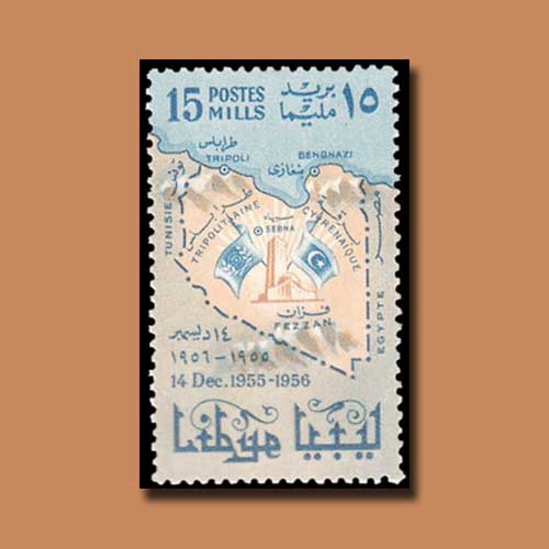
This 1956 stamp shows the provinces that came together to form modern Libya. With an area of almost 1.8 million square kilometers, Libya is the fourth largest country in Africa, and is the 16th largest country in the world.The area which is now Libya was originally a vilayet of the Ottoman Empire which was ceded to Italy in 1912[1] and became an Italian colony. The sovereign state is made of three historical regions: Tripolitania, Fezzan and Cyrenaica.
Postal stamps have been in use since Libya was part of the Ottoman Empire. Italy established the first main postal outlets in order to ensure some sort of a communication link to its residents in the Ottoman colony in this part of North Africa in 1869.
It was not until independence in 1951 and the unification of the three regions of Libya under the name The United Kingdom of Libya that stamps commemorating Libyan subjects began to appear in print. The stamp depicting this unification was issued on 14th December 1956.
The stamp depicts the map of Libya along with its border. The map of Libya is inscribed with the names of the region which came together to form the country. The map shows the parliament building along with two flags. This 15 Mills stamp is inscribed with the name of the country in Arabic and the denomination value in both Roman and Arabic.
Image Courtesy: https://colnect.com
Visit philamart to view and purchase variety of stamps from all over the world.
Latest News
-
Gold Pagoda of Vijaynagar Empire King Deva Raya I
2024-04-10 WedKing Deva Raya I of the Vijayanagara Empire was a patron of Kannada literature and architecture. He ...
-
Silver Denarius of Septimus Severus
2024-04-05 FriLucius Septimius Severus served as the Roman emperor from 193 to 211 AD. Severus sat on the throne o...
-
Extremely rare 'Malaharamari' type Gold Gadyana of King Guhalladeva-III Sold for INR 611000
2024-04-03 WedTribhuvanamalla, also known as Guhalladeva III, was the ruler of the Kadamba dynasty. His reign coin...
-
90 Years of RBI
2024-04-02 TueOn 1st April, PM #Modi unveiled a special commemorative coin marking 90 Years since the foundation o...
-
Silver Denarius of Julia Mamaea
2024-04-02 TueJulia Avita Mamaea, a Christian Syrian noblewoman, was the mother of Roman Emperor Alexander Severus...

