
Science and Technology on Indian Postage Stamps-12
2025-12-08 Mon
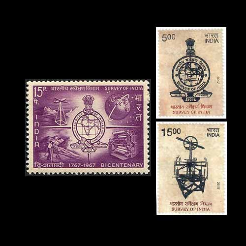
The survey of India (SOI) serves as the principal mapping and surveying agency across the country. Established in 1767, it is recognized as one of the oldest scientific departments within the Government of India and holds the distinction of having printed the first copy of the Constitution of India. The agency is headquartered in Dehradun, Uttarakhand, and operates through 8 zones, 23 geo-spatial data centers, 6 specialized directorates, and 1 training directorate throughout India. Its guiding motto, ‘Aa Setu Himachalam,’ translates to ‘From Setu to Himalaya.’ According to Tarun Kumar Mondal in ‘Mapping India since 1767: Transformation from Colonial to Postcolonial Image’, India possesses a rich legacy of mapping that spans over 2,500 years. During ancient times, Indian scholars demonstrated a profound understanding of concepts such as scale, length, shape, area, and angles. This assertion is bolstered by archaeological findings from the remarkable cities of the Harappan Civilization and references within ancient Indian texts such as the Sulvasutras. The continuity of this tradition is evident in the notable mathematical and astronomical contributions of esteemed scholars, including Aryabhatta, Varahamihira, and Bhaskaracharya, between the 5th and 12th centuries. Furthermore, in the 16th and 17th centuries, Mughal rulers effectively used maps to facilitate administration and streamline revenue collection. Similarly, the Maratha rulers fostered significant advancements in mapping traditions during the 17th and 18th centuries. The establishment of the SOI in 1767 marked a pivotal moment in the history of Indian cartography. It came under the jurisdiction of British colonial authorities who took charge of surveying and mapping the subcontinent. In the subsequent decades, especially during the late 18th and 19th centuries, extensive surveying and mapping efforts were undertaken as more regions were annexed under British rule. These endeavors resulted in the production of maps that were dedicated to notable officials such as Robert Clive and Warren Hastings, the commander-in-chief and governor-general, respectively. This period witnessed the development of various survey types, including Military, topographical, and revenue surveys. The 19th century also heralded the introduction of the trigonometric method, which marked a significant advancement in the surveying process. This innovative approach employed a geometric method for geographical calculations for the first time. The method of measurement through triangulation was conceived by the EIC officer William Lambton, and later, under his successor George Everest, it became the responsibility of the SOI. A remarkable achievement of the trigonometric survey was the accurate measurement of Mount Everest, K2, and Kanchenjunga. Notably, the pioneering mathematician and surveyor, Radhanath Sikdar, accurately measured Mount Everest in 1852, determining its height to be 29,002 feet. Following India’s #Independence in 1947, the SOI was entrusted with the critical responsibility of mapping the nation to facilitate efficient nation-building. In this capacity, the agency has produced a variety of maps for planning and development purposes. Presently, its primary focus remains aligned with addressing the military requirements of the country. Over the years, the SOI has embraced modern technologies, including aerial photography and #uav technology, to enhance its mapping capabilities. India Post has honored the SOI by issuing commemorative stamps on two significant occasions. The first stamp was released on 01 May 1967, to #celebrate the agency’s 200th anniversary, featuring its emblem and mapping methodologies. A second stamp was issued on 22 June 2017 to commemorate its 250th anniversary, showcasing a design that includes the SOI emblem alongside a Mapping machine.Latest News
-
Science and Technology on Indian Postage Stamps-11
2025-12-05 FriDr. Homi Jehangir Bhabha was one of India's most esteemed scientists and is widely recognized as the...
-
Science and Technology on Indian Postage Stamps-10
2025-12-05 FriIn the mid-19th Century, the geological community in Europe and North America recognized the need fo...
-
Science and Technology on Indian Postage Stamps-9
2025-12-04 ThuWaldemar Mordechai Wolff Haffkine was a distinguished Russian-French bacteriologist renowned for his...
-
Gold Tanka of Malwa Sultan Nasir Shah
2025-12-04 ThuNasir Shah, the son of Ghiyath Shah, ascended to the throne of the Malwa Sultanate in the Hijri year...
-
Science and Technology on Indian Postage Stamps-8
2025-12-04 ThuAcharya Prafulla Chandra Ray is regarded as one of the most distinguished scientists and industriali...